A Change in Australian Weather Fortunes
17 June 2026
Northern cropping regions of Australia are heavily reliant on summer rainfall. However, this season autumn rainfall has stepped up to save our new crop planting prospects. After a severely dry late summer and early autumn, planting intentions will improve on solid national rainfall in the months of May and June this year.
Late Summer Grain Rally
In March of this year, we saw a rally in Australian wheat and barley prices for three reasons. One, the Iran conflict rallied all commodities globally. Two, diesel prices spiked causing consumers to have to pay more for grain deliveries. Three, severe dryness and poor soil moisture in New South Wales (NSW) and Queensland (QLD). Western Australia (WA) was also suffering from a dry spell but not to the degree of the East.
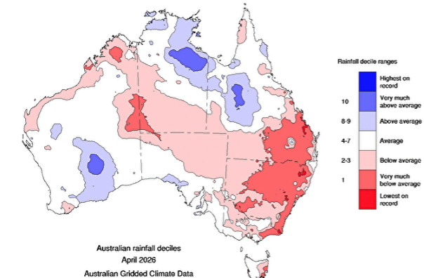
At the start of May the market was beginning to price in a worst-case scenario for the East Coast on the assumption of a much smaller planting program for this season. Driven by this fear, domestic feed markets rallied and growers held back grain sales waiting for improved weather.
Diesel prices spiked on the Iran conflict which added fuel to the fire. Dubbo in NSW recorded an average price of $1.82 per litre before the conflict. This number peaked on April 13th at $3.22 per litre before the government established the temporary excise reduction. This sharp spike in energy costs intensified the situation by sharply increasing freight rates. Amongst all this, northern feedgrain markets began to price a drought and the potential need for imports into QLD.
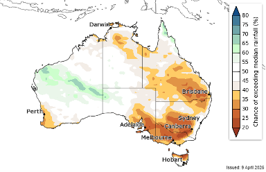
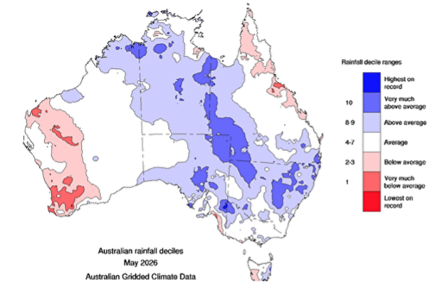
Change in May Weather Patterns
Over the course of May and now June we have seen a much improved soil moisture profile for the East Coast of Australia. Timely rains over this period have also improved the outlook for planting. Grain markets have responded by reducing the risk premium that was priced into NSW and QLD. Victoria (VIC) and, in particular South Australia (SA) continue to look strong. WA has recorded rains in June that have also improved their prospects.
The Status of the current El Nino
On Friday June 13th the US government weather agency NOAA declared we had entered El Nino territory. On Tuesday June 16th the Australian Bureau of Meteorology issued a statement that “the El Nino-Southern Oscillation (ENSO) is now in an El Nino phase”. An El Nino weather pattern increases the chances of the following:
- Less rainfall in the winter and spring in Eastern Australia
- Higher temperatures
- Increased frost risk due to clearer skies
There is no guarantee on this and the balance of the season could go well. However, there is likely to be increased grain market volatility either way because of the outlook.
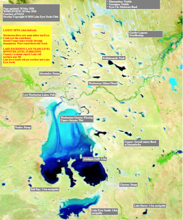
The Lake Eyre Yacht Club
There is an old myth that when Lake Eyre in South Australia is full – it portends for good rainfall in Australia. While cropping areas remained dry, tropical depressions in the North End were refilling the streams and lakes of the center of Australia. Thanks to the Lake Eyre Yacht Club, we can see the below picture of the Lake’s current status in the north central part of South Australia. We remain hopeful that the myth will ring true, and the prediction of an intense El Nino doesn’t come to pass.
As always, we wish Aussie growers a safe, productive and fruitful season.
Share This Article
Other articles you may like